
Magic Earth Navigation & Maps
4.3star
39.6ହଟି ସମୀକ୍ଷାinfo
1ନି+
ଡାଉନଲୋଡ

PEGI 3
info

ଏହି ଆପ୍ ବିଷୟରେ
Find the best route to your destination even without an internet connection. Magic Earth uses OpenStreetMap data and a powerful search engine to offer you the optimal routes for driving, biking, hiking and public transportation.
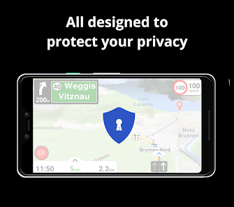
PRIVACY FIRST!
• We do not track you. We do not profile you. We do not trade in your personal data; moreover, we do not have it.
MAPS
• Save big on mobile internet costs and navigate reliably with offline maps powered by OpenStreetMap. 233 countries and regions are ready to be downloaded.
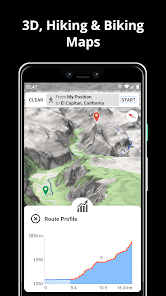
• Choose between 2D, 3D and Satellite map views.
• Get ready for travel and know every detail of your route like surface, difficulty, distance and elevation profile.
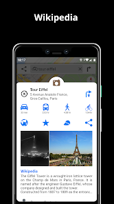
• Learn more about the points of interest near you from Wikipedia articles.
• Spot nearby parking places to easily park your car.
• Stay up-to-date and enjoy regular free map updates.
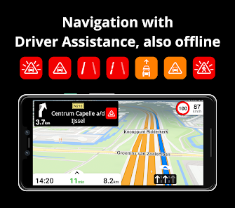
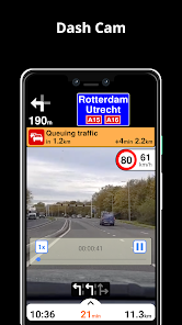
AI DASHCAM
• Improve safe driving and avoid accidents. Receive alerts to potential problems on the road and record your trip.
• AI DashCam features Driver Assistance warnings and Dash Cam functionality.
• Avoid collisions and accidents with Driver Assistance warnings: Headway Warning, Forward Collision Warning, Pedestrian Collision Warning, Lane Departure Warning, Leaving Lane Warning, Stop & Go Assist.
• Record the road ahead during navigation to have an aid in the event of a collision or incident.
• Driver Assistance warnings and Recordings are available when the device is on a car mount in landscape mode, with a clear view of the road ahead.
* AI DashCam (with Driver Assistance warnings and Dash Cam functionality) requires Android 7 or later.
NAVIGATION
• Find the fastest or the shortest route to your destination when you travel by car, bike, on foot or with public transport.
• Plan your route with multiple waypoints.
• Stay safe with the free Head-up Display (HUD) feature which projects the most important navigation info onto the windshield of your car.
• Know in advance which lane to take with precise turn-by-turn navigation and lane assistance.
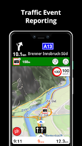
• Get notified about speed cameras and stay up to date with current speed limits.
TRAFFIC INFO
• Get real-time traffic info, updated every minute.
• Discover alternative routes that avoid the traffic jams and save you time on the road.
PUBLIC TRANSPORT
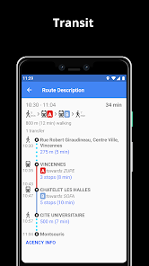
• Get around town quickly and easily. Choose from public transit routes that combine all transportation modes: bus / metro / subway / light rail / train / ferry
• Get walking directions, transfer times, departure times, number of stops. And when available, the cost.
• Find wheelchair or bike friendly public transportation.
WEATHER
• View current temperature and local weather forecast for your favorite locations.
• See what weather conditions to expect in the next hours and view the forecast for the next 10 days.
NOTES:
* Some features are not available in all countries.
* Some features require internet connection.
PRIVACY FIRST!
• We do not track you. We do not profile you. We do not trade in your personal data; moreover, we do not have it.
MAPS
• Save big on mobile internet costs and navigate reliably with offline maps powered by OpenStreetMap. 233 countries and regions are ready to be downloaded.
• Choose between 2D, 3D and Satellite map views.
• Get ready for travel and know every detail of your route like surface, difficulty, distance and elevation profile.
• Learn more about the points of interest near you from Wikipedia articles.
• Spot nearby parking places to easily park your car.
• Stay up-to-date and enjoy regular free map updates.
AI DASHCAM
• Improve safe driving and avoid accidents. Receive alerts to potential problems on the road and record your trip.
• AI DashCam features Driver Assistance warnings and Dash Cam functionality.
• Avoid collisions and accidents with Driver Assistance warnings: Headway Warning, Forward Collision Warning, Pedestrian Collision Warning, Lane Departure Warning, Leaving Lane Warning, Stop & Go Assist.
• Record the road ahead during navigation to have an aid in the event of a collision or incident.
• Driver Assistance warnings and Recordings are available when the device is on a car mount in landscape mode, with a clear view of the road ahead.
* AI DashCam (with Driver Assistance warnings and Dash Cam functionality) requires Android 7 or later.
NAVIGATION
• Find the fastest or the shortest route to your destination when you travel by car, bike, on foot or with public transport.
• Plan your route with multiple waypoints.
• Stay safe with the free Head-up Display (HUD) feature which projects the most important navigation info onto the windshield of your car.
• Know in advance which lane to take with precise turn-by-turn navigation and lane assistance.
• Get notified about speed cameras and stay up to date with current speed limits.
TRAFFIC INFO
• Get real-time traffic info, updated every minute.
• Discover alternative routes that avoid the traffic jams and save you time on the road.
PUBLIC TRANSPORT
• Get around town quickly and easily. Choose from public transit routes that combine all transportation modes: bus / metro / subway / light rail / train / ferry
• Get walking directions, transfer times, departure times, number of stops. And when available, the cost.
• Find wheelchair or bike friendly public transportation.
WEATHER
• View current temperature and local weather forecast for your favorite locations.
• See what weather conditions to expect in the next hours and view the forecast for the next 10 days.
NOTES:
* Some features are not available in all countries.
* Some features require internet connection.
ଗତ ଅପଡେଟର ସମୟ
ଡେଭେଲପରମାନେ ଆପଣଙ୍କ ଡାଟାକୁ କିପରି ସଂଗ୍ରହ ଏବଂ ସେୟାର କରନ୍ତି ସେହି ଧାରଣା ସହିତ ସୁରକ୍ଷା ଆରମ୍ଭ ହୁଏ। ଆପଣଙ୍କ ବ୍ୟବହାର, ଅଞ୍ଚଳ ଏବଂ ବୟସ ଆଧାରରେ, ଡାଟା ଗୋପନୀୟତା ଓ ସୁରକ୍ଷା ପ୍ରାକ୍ଟିସ ଭିନ୍ନ ହୋଇପାରେ। ଡେଭେଲପର ଏହି ସୂଚନା ପ୍ରଦାନ କରିଛନ୍ତି ଏବଂ ସେ ସମୟାନୁସାରେ ଏହାକୁ ଅପଡେଟ କରିପାରନ୍ତି।


ମୂଲ୍ୟାଙ୍କନ ଓ ସମୀକ୍ଷା
4.3
36.8ହଟି ସମୀକ୍ଷା
ନୂଆ କଣ ଅଛି
Bugs fixing and stability improvements
ଆପ ସପୋର୍ଟ
ଡେଭେଲପରଙ୍କ ବିଷୟରେ
Magic Lane International B.V.
Narva-eiland 52
1014 ZJ Amsterdam
Netherlands
+40 744 494 824


