Norgeskart Outdoors
In-app purchases
4.8star
2.88K reviewsinfo
500K+
Downloads

PEGI 3
info


About this app
Norgeskart Outdoors has everything you need for your outdoor activities. Be it hunting and fishing, hiking, cycling, skiing or boating. All functions and content can be made available even without mobile coverage.
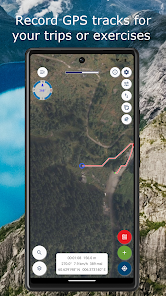
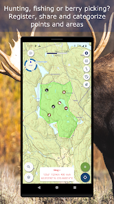
- Register, measure and categorise -
Register points of interest, routes, areas and record tracks. Organise the data by creating your own categories with colors and styles/icons for each category. If desired, your data can be written and read to/from GPX files or synchronised across devices and the map portal norgeskart.avinet.no. You can also easily share files with others from the lists of data in the app.
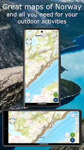
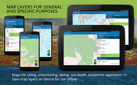
- Great outdoor maps and map layers -
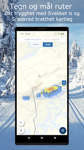
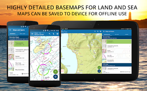
Choose from more than 40 maps and map layers. Beautiful maps of Norway from the Norwegian mapping authorities can be downloaded before you go on a trip for offline use. Many apps only let you turn on one layer at a time, here you can combine as many layers as you wish to create a complete overview of your surroundings. E.g. by turning on Pistes, Avalanche steepness and Weak ice layers.
Norgeskart Outdoors differs from most other map apps in that it supports both Mercator and UTM projected maps. This let it display the high-resolution UTM versions of the topographic maps of the Norwegian Mapping Authority. The UTM services has 2 extra levels of details compared to the Mercator version.
- Own map and map layers -
Are you missing a map or map layer? The app now supports adding your own maps and layers from WMS, WMTS, XYZ and TMS services. A great source for additional maps and layers in Norway is the site geonorge.no. You can also try adding maps from other countries, but the app only support Mercator and UTM33 projections.
- TellTur -
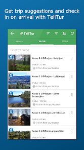
Plan your next trip with trip suggestions and descriptions from telltur.no. With TellTur you can use the app to register when you arrive at a tour destination and compete with others to visit the most places.
This app contains both free and paid content (see complete overview below). By paying for a subscription, you support the further development of the app and take full advantage of all the exciting things we have to offer.
Free content:
------------------
- Mercator topographical and nautical maps for Norway, Svalbard and Jan Mayen
- Open air routes summer and winter
- Steepness with run out
- View place name and heigh/depth for cursor position
- Search for place names, addresses or coordinates
- Import and export of GPX files
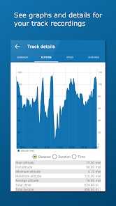
- Track recording with diagrams and details
- Create routes and POIs
- Compass
- Property borders
Pro subscription:
------------------
- Download Norwegian maps for offline use
- Extra detailed UTM versions of topographical maps
- Create and measure areas
- Create own categories
- Topo map of Sweden (offline, but without download area function)
- Upload POIs, tracks and routes
- Synchronize your data across devices and with map portal
- Advanced properties layer (cadastre)
- Economic (N5 raster) map
- Historical map
- Trails
- Mountain bike routes
- Pistes for Alpine and Cross-country
- Avalanche awareness and incidents
- Weak ice
- Snow depth and skiing conditions
- Snowmobile tracks
- Sea depths and lake depths
- Anchorages
- Conservation areas
- Clay and radon
Pro+ subscription (199 NOK a year):
------------------
- All in Pro
- Orthophoto maps for Norway and Svalbard
- Add your own maps and layers
- Bedrock map layer
- Periodic update of points from online KML files. Tested with TeleSpor.
- Register, measure and categorise -
Register points of interest, routes, areas and record tracks. Organise the data by creating your own categories with colors and styles/icons for each category. If desired, your data can be written and read to/from GPX files or synchronised across devices and the map portal norgeskart.avinet.no. You can also easily share files with others from the lists of data in the app.
- Great outdoor maps and map layers -
Choose from more than 40 maps and map layers. Beautiful maps of Norway from the Norwegian mapping authorities can be downloaded before you go on a trip for offline use. Many apps only let you turn on one layer at a time, here you can combine as many layers as you wish to create a complete overview of your surroundings. E.g. by turning on Pistes, Avalanche steepness and Weak ice layers.
Norgeskart Outdoors differs from most other map apps in that it supports both Mercator and UTM projected maps. This let it display the high-resolution UTM versions of the topographic maps of the Norwegian Mapping Authority. The UTM services has 2 extra levels of details compared to the Mercator version.
- Own map and map layers -
Are you missing a map or map layer? The app now supports adding your own maps and layers from WMS, WMTS, XYZ and TMS services. A great source for additional maps and layers in Norway is the site geonorge.no. You can also try adding maps from other countries, but the app only support Mercator and UTM33 projections.
- TellTur -
Plan your next trip with trip suggestions and descriptions from telltur.no. With TellTur you can use the app to register when you arrive at a tour destination and compete with others to visit the most places.
This app contains both free and paid content (see complete overview below). By paying for a subscription, you support the further development of the app and take full advantage of all the exciting things we have to offer.
Free content:
------------------
- Mercator topographical and nautical maps for Norway, Svalbard and Jan Mayen
- Open air routes summer and winter
- Steepness with run out
- View place name and heigh/depth for cursor position
- Search for place names, addresses or coordinates
- Import and export of GPX files
- Track recording with diagrams and details
- Create routes and POIs
- Compass
- Property borders
Pro subscription:
------------------
- Download Norwegian maps for offline use
- Extra detailed UTM versions of topographical maps
- Create and measure areas
- Create own categories
- Topo map of Sweden (offline, but without download area function)
- Upload POIs, tracks and routes
- Synchronize your data across devices and with map portal
- Advanced properties layer (cadastre)
- Economic (N5 raster) map
- Historical map
- Trails
- Mountain bike routes
- Pistes for Alpine and Cross-country
- Avalanche awareness and incidents
- Weak ice
- Snow depth and skiing conditions
- Snowmobile tracks
- Sea depths and lake depths
- Anchorages
- Conservation areas
- Clay and radon
Pro+ subscription (199 NOK a year):
------------------
- All in Pro
- Orthophoto maps for Norway and Svalbard
- Add your own maps and layers
- Bedrock map layer
- Periodic update of points from online KML files. Tested with TeleSpor.
Updated on
Safety starts with understanding how developers collect and share your data. Data privacy and security practices may vary based on your use, region and age. The developer provided this information and may update it over time.

No data shared with third parties
Learn more about how developers declare sharing

This app may collect these data types
Location and Personal info

Data is encrypted in transit

You can request that data be deleted
Ratings and reviews
4.7
2.63K reviews

Berrit Bredemeier
- Flag inappropriate
8 August 2023
I love the app, but recently had issues with track recording, the starting point is always set to my home. I can delete that after saving, but it prevents me from checking how far I've come during recording. For later editing I would also like to have an option of applying different colours to the tracks and adding points in-between to correct faults.
Ture Apps AS
8 August 2023
Hi. If you let the GPS update its location before starting the tracker, you should avoid the problem with the start point. I will also add a check in a later version. There will soon be possible to add your own categories with style and colour for tracks, routes etc. I will also look into allowing adding of points to recorded tracks.

Toby Marchant
- Flag inappropriate
21 June 2022
We've been using this App for a two week trekking holiday in North Norway and found it extremely useful. It has proved to be very accurate especially where paths are not marked or become lost in boggy ground or woods. My only slight annoyance is the difficulty understanding the legend. There seems to be very little difference between many of the symbols unless there is something I have not understood. The legend page cannot be expanded either making it even harder to read.
1 person found this review helpful
Ture Apps AS
6 July 2022
Hi. Thanks for your nice review. There is not much I can do about the legend itself as this is provided by the different external map services I use. But I will look into improving the display of the legends with zoom capabilities when I get the time. Thanks for letting me know :-)

Geir Olav Løken
- Flag inappropriate
14 May 2023
I've been using this app since it was launched. It gives direct access to the analogue maps in Norwegian governments official map database. The apps nautical base layer charts are the same as the official paper charts. It is really all you need for navigation at sea and on land in Norway. When sailing for extended trips, I just make all the crew download the app and pan over our cruising area at various magnifications so that the app stores maps in case we end up offline.
2 people found this review helpful
Ture Apps AS
24 May 2023
Thank you for the review. Nice to hear that you appreciate the app so much :-)
What's new
Fixed problem with perm_denied during upload and download of registered data that some users might experience. User is asked to log in again.
App support
About the developer


